Tornado Watch Issued For Webster
National Weather Service
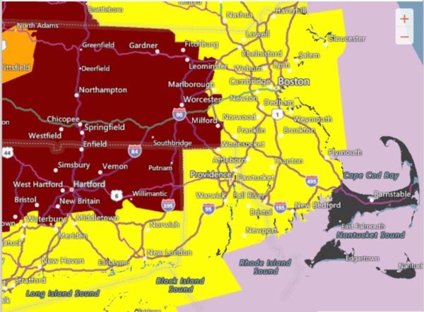
The National Weather Service has issued a Tornado Watch for the immediate Webster area, including as far north to Worcester, Fitchburg and as far south as Putnam and Willimantic. It does not include Rhode Island at this time. The rest of the area is in a Severe Thunderstorm Watch.
It will stay in effect until 9PM on Tuesday, May 15th. Watch out for dark, rotating clouds. If you see one, take shelter immediately!
Knowing the difference between a watch and a warning is important.
Watches are issued by by local offices of the National Weather Service, when conditions are favorable, for either for a severe thunderstorm or tornadoes. It doesn’t necessarily mean severe weather is imminent.
Warnings mean that severe weather is imminent and is based on specific criteria and existing reports received by the National Weather Service.
The criteria include hail that totals more than 1 inch in diameter and wind speeds of 55 mph.
If you believe you see a tornado, take shelter in a basement or bathtub. Flying debris from high winds causes most injuries. Stay away from windows. If you’re outside, lie down in a low, flat area and cover your head with your hands. You’re safer lying down than standing up.
THE LAKE 940 is your official ACCUWEATHER Station and will keep you informed with the latest weather on the radio and also here on Lake940.com